


lacs ténine et lispach

Specialized77
User GUIDE
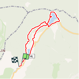

Length
7 km

Max alt
944 m

Uphill gradient
141 m
Km-Effort
8.9 km

Min alt
836 m

Downhill gradient
164 m
Boucle
Yes
Creation date :
2019-08-15 13:34:20.6
Updated on :
2019-08-15 15:54:30.655
2h19
Difficulty : Very easy

FREE GPS app for hiking
 SityTrail
IGN / Geographical institutes
SityTrail Plus
The world is yours!
About
Trail Walking of 7 km to be discovered at Grand Est, Vosges, La Bresse. This trail is proposed by Specialized77.
Positioning
Country:
France
Region :
Grand Est
Department/Province :
Vosges
Municipality :
La Bresse
Location:
Unknown
Start:(Dec)
Start:(UTM)
345457 ; 5322549 (32U) N.
Comments